Showing posts with label Co. Tipperary. Show all posts

Tuesday, 31 October 2017

On the banks of Lough Derg.

A pictorial tour from the banks of Lough Derg where the mighty River Shannon flows,
past the counties Clare and Tipperary.


Autumnal colours at Mount Shannon


It was with sorrow that we found an inconvenient Convenience.


It does make me wonder about the sincerity of the local administrators,
 closing down buildings such as these.
 Where do they expect needy visitors to relieve themselves ?

It is against the Law in Ireland to relieve oneself within in a public area 
irregardless of whether private parts are actually visible - even behind a tree.


In Mount Shannon harbour a foreign ( Dutch ?) craft is for sale.


I found her stern quarters as attractive as her bow and especially the yellow detailing.


The mascot of the Iargo Sneek.


From the banks of east Clare across a placid Shannon to Tipperary.

I think that the tower house, bottom right is Castlebawn which was restored in 1995


Lots of islands loiter creating dreams for some.


In case you are wondering I am not focussed on the tree :-)


More islands lurking near the banks of Clare can be seen when in County Tipperary.


From Portroe in Tipp to the misty mystique of county Clare.


In the foreground an old sleeping ground of yesterday's people lie silently slumbering.


I hope that you have enjoyed this photographic visit
as much as I have in sharing them.




Wednesday, 24 May 2017

SAFE HAVENS


Following our visit to Woodfield’s Cottage Market we took ourselves off on an adventure.
Driving along the roads of Tipperary, which border the banks of Lough Derg, we visited a couple of the harbours which provided safe havens for the pleasure craft that sail its’ waters.

A crowded signpost with misleading signs
because the road sign did actually
read COOLBAUN.


Brockagh Harbour
the name translates to na brocaĆ­ and may mean a dirty (muddy ?) place. 
It certainly has nothing to do with badgers for it is very low lying 
and floods in the winter.


Map of an interesting walk for those whose legs are up to it !


Dromineer Harbour


The name Dromineer in Irish is "Drom Inbhir"
meaning the back or the ford of the river. 


Well, this one could certainly carry a lot of baggage!

Here is an old lady named Miranda that is made of iron - I bet she could tell some tales!

On the skyline are the hills of County Clare in the Province of Munster.
County Tipperary in the Province of Leinster is a long county that shares it boundaries with two provinces in seven other counties: Waterford,Cork and Clare in Munster, Limerick, Kilkenny, Offaly and Laois in Leinster and Galway in Connaught. Five of these are land borders apart from Clare and Galway, which are watery borders. These two counties are divided by Lough Derg, Loch Deirgeirt, meaning "loch of the red eye”’

Ireland’s longest river, The Shannon, which takes its’ name from the goddess Sionnan, flows through the Lough to emerge on her way to the sea on the far side of Limerick City.


Those of you looking for a place to live in Ireland with a grand view 
of Lough Derg might consider this?

Dromineer Bay


Tuesday, 9 May 2017

The Hill of Truth !

Our intention this time was to visit several places that Mrs. H has had her beady eye on for the past few weeks so at the weekend we set off on a round trip of two hundred and thirty-three miles. The weather was perfect, the coffee in the flask was strong and the road was ours.


Apart from visiting the places that were on our schedule, my navigation brought us to a small home that I had long heard about but had never seen. Finding it was a surprise and a treat for sore eyes.

Eamon De Valera’s home-place at Bruree in Co. Limerick. 


&


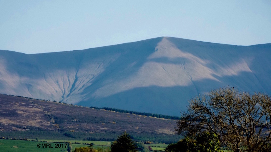
The Galtee Mountains
photo taken from Lattin in Co. Tipperary

The highest peak in the Galtee range is Galtymore which rises to 917 m (3,009 ft). Although not the highest mountain in Ireland it is very impressive and can be seen as a great backdrop on the skyline. Some of the best views can be found when approaching Cashel, Co.Tipperary from the north and onwards towards Tipperary Town. 
The Galtees are classified as having a High Fall risk for ramblers, with steep and dangerous areas as well as being very wet underfoot so great care must be taken when walking there.  


My favourite view of The Galtees

By mentioning The Galtee Mountains and Eamon De Valera it has brought to mind a song about a comrade-in-arms of his which I share with you here:

The song of the Galtee Mountain Boy


We continued along our route, travelling further south until we finally saw the outline of Cnoc FĆ­rinne, Co. Limerick. Known as the Hill of Truth or of truthful prediction, because it serves as a weather glass to the people of the surrounding plains who can predict whether the day will be wet or dry by the appearance of the summit in the morning. It is here by tradition that the Irish God, Donn, has another home. 

The Hill of Truth

Cnoc FĆ­rinne

I find it humorous that the male gods are more than likely to be found in the high places and associated with weather, death and truth, whilst their female counterparts are generally found lower in the landscape, in caves, valleys and rivers. 


On the drive home we both felt a bit weary and yet satiated from all that we had seen, the happy memories of which will remain with us. Thank you for visiting this blog and I hope you have enjoyed reading it as much as I have enjoyed sharing it.


Monday, 30 November 2015

Brian Boru and Old Magic

Cashel town

On Saturday morning we were up early (for us) to drive down to Cashel in Tipperary in order to meet with some friends. They were also driving down from somewhere in Cork.

Has that confused you ?

Here in Ireland no matter where you live or in what direction you are going the phrase used is ‘going down to’, people who live on the south coast will 'travel down to’ places in the north.

For a few days I had been keeping an eye on the weather forecasts to see what we could expect.
On Saturday morning there was an orange alert for a high, west wind and heavy rain with a variable temperature of 4 to 7 deg C. 
"Damn to hell" I thought that can’t be right, "ah’ we will give it a go anyway."
So we did.  As we left home the temperature was 5.5 deg C but after a few miles it rose to 7.4 degrees. I sat in the front passenger seat and in my mind kept focussing on seeing blue skies over Cashel.

When stopped for a while in Urlingford to have a sandwich we had sleet falling on the windscreen. That did not deter me though as I kept on focussing on fine weather. We arrived at our destination, the temperature had risen and it was dry but with a chill wind. We finally met our friends and repaired to a pub.We sat in a window seat chatting away and drinking coffee. Nothing stronger as alcohol during the day makes me sleepy and I recall, when I was a 'dry’ driver, how annoying the fumes of strong drink could be.
Towards the end of our meeting a burst of sunlight shone through the window and as I looked up the sky was blue. “Ah-hah the old magic still works” I thought to myself.


The Rock of Cashel

Outside the pub we said our goodbyes and returned to the car park in a strong biting wind, we were very glad of the shelter that the car provided. 
On leaving the town I asked her Ladyship to pull over so that I could take a photo of The Rock of Cashel from whence the town of Cashel gets its name.

In the 5th century, the Eóganachta dynasty founded their capital on and around the rock and many kings of Munster have reigned here. In 977 the DĆ”l gCais usurper, Brian Boru, was crowned here as the first non-Eóghanacht king of Cashel and Munster in over five hundred years. His great-grandson, King Muirchertach Ua Briain, gave the place to the bishop of Limerick in 110, denying it forever to the MacCarthys, the senior branch of the Eóganachta. 
The bishops once had a famous school in Cashel and from there sent priests all over the continent.They even maintained their own monastery, called Scots Monastery, in Regensburg, Germany.

These days Rock is under the care of Heritage Ireland whose scaffolding can be seen over Cormac’s Chapel.
The project underway currently involves conserving the chapel, built from sandstone, which has deteriorated to such an extent that it is letting in water. 
A notice on their web site explains that access to the Chapel is limited from May till September each year for bus tours until the work is completed. Visitors are admitted in small groups for 10 minutes maximum.

We had a great day out and by the time we had returned the temperature had risen to 10 deg, which proves that it is unwise to believe everything that the experts tell us.
Our next adventure will be ……. ah you will have to wait and see :)

Thursday, 25 December 2014

Drunken journalists ?


The first journalist provides great amusement or even irritation with their ignorance in the geography of Ireland.

From RTƉ NEWS Wednesday 24 December 2014 21.33

“An investigation by the Air Accident Investigation Unit is underway after a small plane crash landed in a field east of Portumna, County Galway.
The four-seat plane was en route to Galway from the UK when the pilot was forced to make an emergency landing in a field outside BorrisoKane, County Tipperary.

Portumna is small town on the banks of the River Shannon providing a watery division between the west and  the midlands of Ireland so any field to the east of  Portumna has to be in a neighbouring county and it is not clear as to why Portumna needed to be mentioned in the article.


****


And from The Irish Times Wed, Dec 24, 2014
Journalist Genevieve Carbery who has masters degrees in both equality studies and journalism writes :-

“In what has almost become a Christmas Eve tradition, singer Glen Hansard led **a rabble** of musicians in song to a crowd of hundreds on Dublin’s Grafton Street” busking for The Simon Community among who were Damien Rice, Mundy, Paddy Casey, Liam O’Maonlai, Declan O’Rourke, Danny O’Reilly from the Coronas and Danny O’Donoghue from the Script

RABBLE: meaning people, who are regarded as socially inferior or uncouth, the use of this word is completely out of place and untrue.